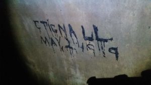
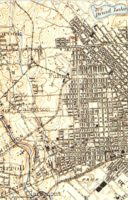
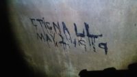
 Zoze had contacted me stating that he and some of the boys had stumbled across some “etchings or writings” in Lower Gwynns.
[“we finnally made it to the backbreakers and the final tubes. found old etchings from the early 1900’s in an older section yet to be explored.”]
I knew he was on to something interesting. Zoze had been “drain blazing” hard and consistently for the past year. bringing so many successful stories of discovery accompanied by beautiful documentation of the Public Works.
Traveling up Lower Gwynns Interceptor, a junction chamber is met dated 1924 per GIS. The interceptor turns into 2 trunks now.
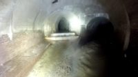
Continue straight forward into a semi-elliptical which will be referred to at this time as [New Lower Gwynns Trunk]. GIS dated 1928. This tunnel is emptying the lower portion of Gwynns Run proper. The stream rolls off of 2 longish platform like stairs/drops.

or
Bear right under an older elliptical arch, which will be referred to at this time as the [Franklin & Pulaski Streets Drain] the underground outfall section tunnel that host the writings was likely built between 1908-1919 (ref?). The stream from this outfall rolls off a series of large sized block drops

— In a sense you must step up into this underground stream. For this reason, the tunnel appears smaller then what it is, that is, until you step up, inside of it. Coincidentally this branch gets larger and older the deeper you push back into it. [Look for an upcoming article titled something to the tune of “Rolling 6 Man Trip Deep in the Depths of Eastern Gwynns.”]
Immediately inside the eastern branch, you are met with what appears to be “Miners Graffiti”. a few 2 letter initials sparsely scattered about. Its not graffiti as you would imagine it in the modern sense but crude writing using carbide lamps. Carbide lamps were widely used by miners and tunnel diggers up until 1932 after the Moweaqua Coal Mine disaster.
The one writing that became of great interest was written in a paraffin / wax like material.
There was one “mural” that became of great interest to myself and the boys. And that was the one that read “CTiGNALL MAY, 2 1919”.
Name & Date
CTiGNALL – This likely is the last name of a Welsh man. Or It could be the first initial C, last name Tignall? Why Welsh though? First gen Welsh immigration to the Eastern portion of the United states was prominent during the 1850’s – 1900’s. Maryland’s Piedmont plain offered an abundance of work in the underground . Welch workers were first known in Maryland as quarry men, digging out Peach bottom Slate (ref.a).
I reached out to a contact of mine who has Welsh roots however now living in England. He agreed that this likely an old Welsh last name. But could not conjur anything more specific about it.
Date – Now whats interesting is per GIS, that junction chamber build completion was 1924. Just a few years after 1919 and the dates of throughout the eastern tunnel is largely unknown.
Franklin & Pulaski Streets Drain, was likely an open air outfall before it was buried and eternally entombed. In other words, we can appreciate from a number of sources that this stream was buried before lower Gwynns Run proper was. And Back then it would empty out into the open air stream. Perhaps this outfall was hidden by a thick patch of blackberries. However still accessible by its community it served. Whats to say that the society back then , did not have a natural curiosity to climb around this structure or a Hobo vagabond would not make use of an area like this as a temporary haven like we see today.
The last time we see Gwynns Run Eastern Branch as an open air stream is 1904.
Google gives only 4 results for this query. Only one of those results are remarkable. In that it links to a publishing dated in 1899 by the “New England Railway Publishing company” titled “A B C Pathfinder Shipping and Mailing Guide”.
If you have something to add or I got something wrong. Contact me and let me know.
Reference/Sources:
ref a.) National Register Properties, https://mht.maryland.gov/nr/NRDetail.aspx?NRID=1486 retrieved 9/26/2019
b) https://ngmdb.usgs.gov/topoview/
c) https://en.wikipedia.org/wiki/1932_Moweaqua_Coal_Mine_disaster , retrieved 09/03/2019
d) “A B C Pathfinder Shipping and Mailing Guide”, New England Railway Publishing company., 1899
e) GIS
Last edited ://
09/01/2019 – creation
09/26/2019 – published

