CSO / SSO #72 | Widowmaker’s Purge |


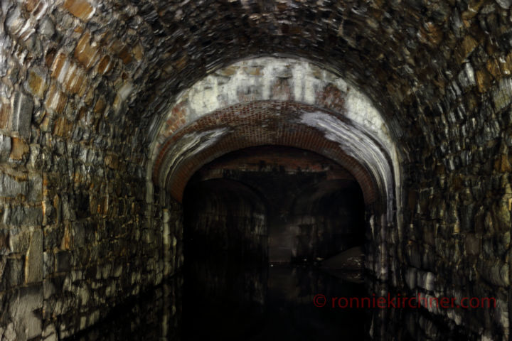
Behold the infamous “SSO #72”, the systems most loathesome of all of Baltimore Sewer Systems purge points. It’s the sewers and residents of Baltimore city’s North East corridor, second chance and hope, during times of heavy precipitation.


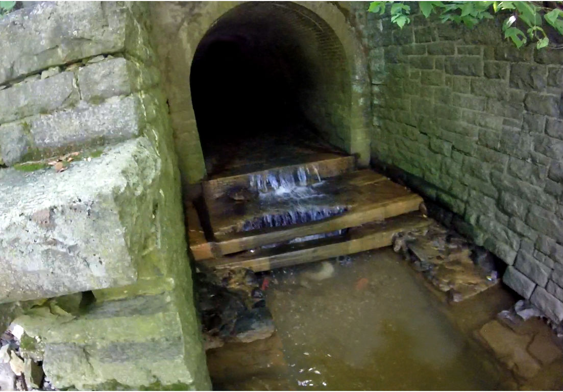
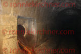
It was cutting edge at its time and for the time being still serves its purpose well. It sits approximately 200 meters deep inside of the Jenkins Run Drain. Left hand side, not long after the first accessible manhole portal that sits on the right. The flap valve resembles the other observed CSO/SSO discharge points in system, that have this sort of flap valve. Exactly as you see it. The brilliant and strategic design choosing the Jenkins Runs drain to bleed itself. Ultimately, the perfect interceptor to do this job. Already built to accommodate a high volume of discharge, figuratively speaking, Jenkins Run really is like the I-83 of sanitary sewerage, quick release, straight shot into the Underground Jones Falls River.

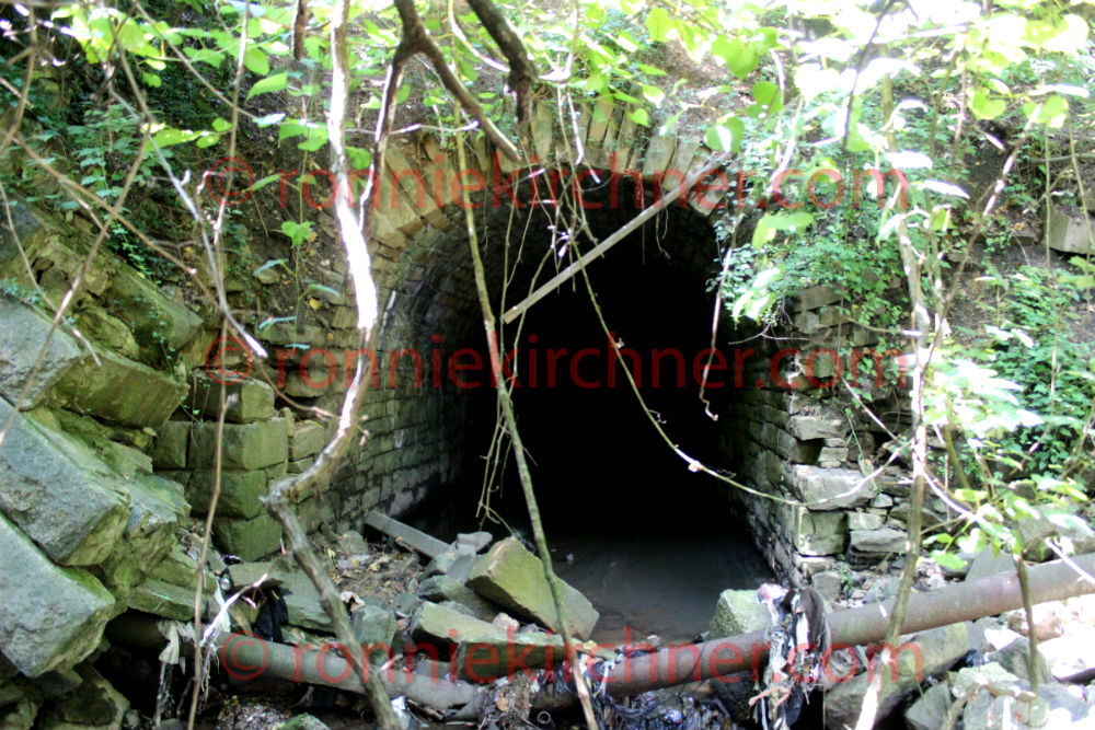
Oh the news, the press that CSO/SSO #72 receives. Its practically famous. However, after a visual inspection of Outfall No. 72 at 428 East Preston Street, one cannot place blame on it for all the building problems they are having over there. There are reports of cracks showing up on the walls of buildings, lamp post settling straight down into the ground. Well its not Outfall / SSO / CSO #72 thats causing this. Its the settleing of the earth that was never there in the first. That is when the Jones Falls River was engineered to make a sharp bend south and that whole area was back filled with dirt. At any rate, focusing on another gripe of Outfall #72 and that is the discharge of sanitary sewage into the river. Its well known that accumulations of sewage into entities of water does not phase well for life but sometimes rising to the top means taking risks. And that’s exactly what happened through 1904-1912. The city laid the most advanced sewage system of its day. The inherit risk being, the lack of funding and budget to undertake the same sort of advanced momentum that the city once had but during the 20th century.

  • CSO/SSO with the highest volume (>4,000,000 gallons) of underground discharges (ref 1.)
  • CSO/SSO with the highest duration (>600 minutes) of underground discharges (ref 1).

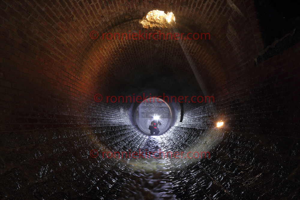
If she opens when your downstream coming up, your in a heap of trouble. If she releases and while your still north of her coming back out, your finding another way out or going to be holed up a while.

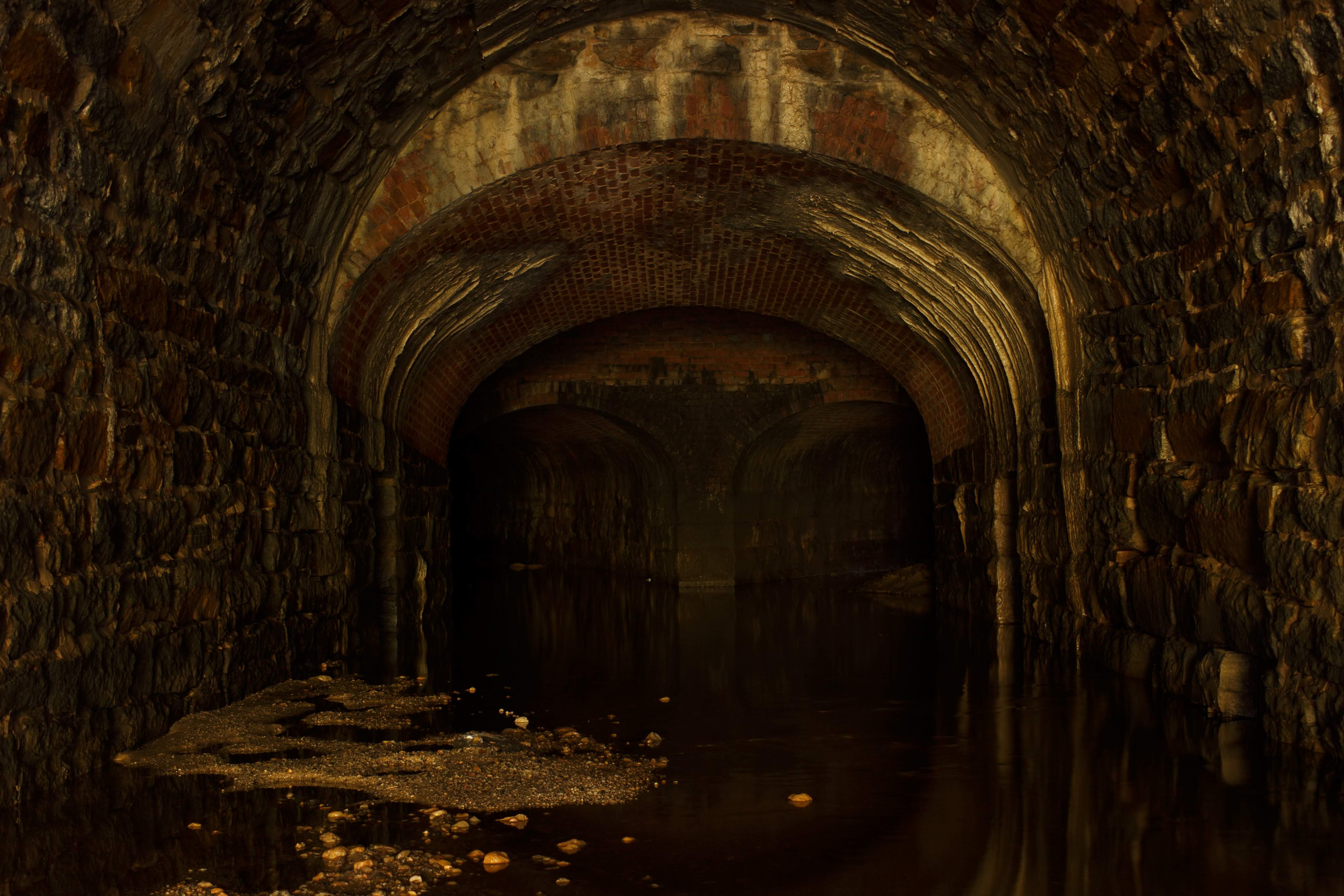
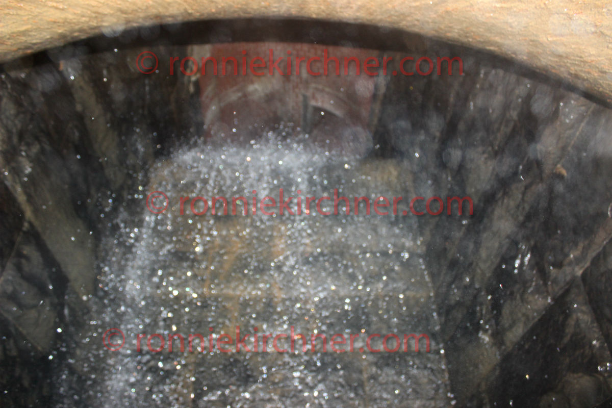
Judging by the size of the iron pipe, it most likely discharges at pressure. Slamming against the tunnels wall that sits 12 feet away. The outer iron pipe is approximately 30cm (12 inches) and while peering inside a smaller iron pipe is met approximately 15cm (6 inches) in diameter.

Image is copywrited. Full resolution image available by request and/or persmissions.

Reference:
1) https://publicworks.baltimorecity.gov/cso-sso-notifications

M.J.MM Storm Sewer


Drains McMechen respectively, including Mosher and John. Was relieved by Druid Hill/ North Avenue Intercepter. It varies in size from an arched culvert 12 feet wide and 15 feet high to a circle 4 feet 6 inches in diameter. Drains out the Rutters Run Lateral. An old, forgotten, buried yet ever present stream. Extensive system with 2 significant junction chambers. Its tunnel system drains out an area known to be notorious for small streams,springs and quicksand. The same engineering grief was had during the construction of the B&O railroad tunnel that lies just north of this tunnel. Exploration of these tunnels requires a man raft as it is block by a deep pit of water of unknown depth. It was once thought that a man raft would be required to access this system but later explorations proved otherwise. However, it has come to our understanding that old drains suffer from deep silt deposits and stagnant air making their penetration and documentation quite treacherous.

Exploration & Discovery Abstract

This tunnel lies within the zone of Baltimore’s “Forgotten Triangle”. For years this tunnel was missed, as it is tucked away in thick brush and mangled railroad waste and appears irrelevant to the untrained eye on satellite imagery. However, one day, the explorer took note of a small, slow flowing stream (almost stagnant in some places) that was tucked away in the corner of the Forgotten triangle. It was decided to follow this stream, with little hopes that it would turn up anything more then a small stone storm drain. The terrain leading up to the drain is treacherous. Mangled, metal and trash strewn everywhere making the explorer cognizant of every step he takes. There is evidence of old foundations and structures and a reconstructed railroad utility. bridge After about a 10 minute traverse, you don’t see the tunnel until your right on top of it due to tree branches and snake like vines covering its entrance. At this point, its like your down in a hole. The side embankments are about 15-20ft above your head but the stone granite arch tunnel itself is like bored into a 40 foot high embankment.

storm drain outfall M.JMM
M.JMM Outfall Tunnel looking in.


North Avenue and Druid Hill Avenue Storm Sewer Tunnel


north ave howard st final outfall
West side Storm Sewer Interceptor
Large interceptor storm sewer drain system built to drain out an area that was known to have many small streams and springs. A 2 fold problem existed, the old Druid Hill Avenue storm sewer was of insufficient capacity and the old McMechen Street Drain was already at over capacity. 2.1 meter (7 ft) oval , Brick Arched Culvert, with a masonry granite floor laid in American hydraulic cement 14 inches thick. This drains drops significantly in elevation along its course to outfall and accomplishes this via multiple vertical drop shafts or vertical drop wells (4 total).


Adventure/ Urban Exploration Video shot soley on a GoPro Hero+ and Canon T3i in this exact drain found below.

Vertical Drop Shafts featuring shafts constructed out of granite masonry that was laid 8ft x8 ft deep square outer diameter (OD), with final sizing 4ft x 4ft internal diameter (ID). The original iron cradles sit at the bottom of these shafts to smoothly drop the water from elevation to the floor. These iron cradles have proven to a very robust and enduring construction method. 1 significant junction chamber. Extensive small laterals. 1.5 percent grade.
In connection with the above were constructed the outfall of the sewer of heavy rubble broken range masonry at the west side of Jones Falls with its wing walls parapet and timber apron the four vertical drops eight feet square with cast iron inverts and the sides and ends faced with heavy dimension stone with depths of eighteen six and one half four and one half and five feet respectively the first two being excavated in hard and rotten rock requiring blasting On the line of the main tunnel four shafts were constructed to depths of 27ft, 43ft, 41ft, and 28ft feet respectively for the purpose of hoisting and lowering materials for the construction of the sewer Of the above there was completed during the year 1895.(ref a.)

Apparently this old storm sewer got in the way during the construction of a section of the B&P tunnel. Later they ended up utilizing it for the drainage of the train tunnel. Reference below.

Another unscheduled problem was encountered in the John Street Tunnel where a storm sewer crossed under the invert after following its centerline for about 200 ft. Originally an old brick-lined barrel and arch, its top had been partly uncovered, probably during invert work in 1916-1917, and slabbed over. Because this structure was at a higher elevation than indicated on the plans, it was severely damaged during invert scarification. (ref b.)

It should be noted that this particular drain had an incident of surging during its first exploratory documentation. The reason to this day is unknown. No precipitation was recorded that day in the area served by this storm sewer let alone watershed. Documentation exist that a section of the John Street tunnel, that passes near by requires water pumps to pump out a low lying area inside the tunnel. It specifically states that the water is pumped into a nearby storm sewer. It can only be assumed that it does so in intervals, such as like a sump pump behaves, which in turn would explain the sudden surge of water. Referenced to this coming soon. here: The sumps were located under the tracks at the south portal to cut off the entrance of outside water supplementing the original pumping chamber, and in the Wilson Street Tunnel just short of the rock line of the intersection with the tunnel invert. Water from the sumps is pumped to the city storm sewers. (ref b.)


north avenue at drop well

REFERENCE
a.) Annual Report of the City Commissioner to the Mayor of Baltimore 1889
b.) Rehabilitation of Amtrak Baltimore and Potomac Railroad Tunnel in Baltimore, Maryland. Pg 31-33, June 1981

Exploration Journal 1: Lower Gwynn’s Run Storm Drain

This tunnel system was yet again discovered through research of historic maps. Gwynn’s run was a significant branch that emptied into the Gwynn Falls River. After the discovery of the M.J.MM Storm Sewer Outfall the writer began focusing more research on the West Side of Baltimore. The Gwynn’s Run branch is clearly seen in early historical maps. When researching old sewer and storm sewer maps, a large number of existing drains and planned construction drains were seen to dump into this open air branch. The branch does not appear on modern day maps and stop appearing in the early 1900’s. Where did all this volume go? There was only one way to find out and that was to go out and explore the area. To uncover what Google Satellite view and Bing Birds Eye view did not reveal.

Accessing the lower portion of this tunnel system initiatlly had its hurdles and considerations. Your in the heart of the Murda-land, Bmore Bodymore. So there is always the concern that you will come back from an explore and find your vehicle’s windows bashed out and on blocks. Then you have to figure out how to get there by not crossing private property. An urban patch of woods, that was visualized from satellite view and now im enveloped inside. Unknown territory, senses on high, living the summer explorers dream. Topographical sense kicking in now, a few animal/bum trails one could follow, many that lead too thorn bushes and poison ivy patches. Following the trail that drops in grade proved successful, and by this time that distinctive sound of water colliding with rocks can be heard but not seen through the thick overgrowth.
Proceeding forward by ducking through natural holes found in poison ivy patches, still unsure if this time spent will pay a dividend. A large creek suddenly becomes visible. By the time you reach a broken concrete embankment the smell of sewer fresh is strong and you realize that your trouble was well worth this reward.

A massive 6 meter high granite arch that has held up since 1829 towers over you with a very distinct keystone at the center top. The retaining wall soars even higher then this. The area around this outfall is like a waste land. Trash and debris like mangled metal, pieces of furniture, tires, car parts, railroad waste strewn everywhere covering the rocks. Debris stuck in the branches of the surrounding trees, this place must rip during storm surges. A flood stage gauge sits in at the tunnel entrance. The drains potential capacity is hinted at by the gauge rising nearly to the half way point of this outfall.

There is a convenient little 12 inch ledge that follows the base of the tunnel and takes a right angle into it. When you peer around the corner, air is just blasting out of there. Pushing further in about 10 meters, you quickly realize that this ledge drops off out of site into deep murky, cloudy water. Only God knows what lies at the bottom and its most likely quite deep after a 175+ years of storms ripping and eroding a trench through there. (It was first thought) that further explorations will require a man raft or something to float you in there The main outfall seems to continue about 50-70 meters or so and takes a sharp easterly bend. Its interesting that large boulders seems to be built or left in place at this bend. Which makes sense as its a sharp artificial turn in the river and those boulders must receive a brunt of the water pressure and friction as the creek obeys the tunnels command.

In my writings, I seldom mention that I’ve really come to learn that water can produce strange acoustics in underground confined spaces. Sometimes its almost like the chattering of a crowd of people at times. I will highlight that the sound coming from inside this tunnel that bent out of sight was quite eerie to say the least. Its hard to describe, its almost like you could hear a group of men working back in there.

A crude attempt to estimate a typical summer storm surge discharge volume: When comparing the data of 3 USGS monitoring sites The rough calculation was done by taking the measured stream discharge volume, at the Villa Nova stream gauge which sits upstream and then adding the measured discharge volume of Dead Run, a tributary that dumps into the Gwynn Falls River proper. Subtracting the sum of the 2 measured discharge poitns, by the total measured discharge of the Gwynns Falls River discharge gauge at Washington BLVD with the difference being associated with buried portion of the Gwynn Falls Run system. The rough numbers seem to suggest that the Gwynn Falls Run Storm Sewer accounts for 20% of the over all final discharge of the Gwynn Falls River during periods of storm. The rough data seems to show that the drain would output 250-300 cubic foot a second during a typical 0.4″ of rainfall summer storm. More treacherous guesstimates were performed, trying to conclude the theoretical capacity of a arched culvert that is 5.7 meters wide and 6.1 meters high at the top of the arch. Not knowing the formulas for calculating the capacity of an arch, the length of this section and variables such as slope it wouldn’t be surprising if 1000+ cubic foot a second could discharge via the outfall.


USGS 01589330 DEAD RUN AT FRANKLINTOWN, MD
USGS 01589300 GWYNNS FALLS AT VILLA NOVA, MD
USGS 01589352 GWYNNS FALLS AT WASHINGTON BLVD AT BALTIMORE, MD

Photography Consents Are Real


What made this experience/scenario unique was the truth behind the photo and the velocity of a key number of consecutive events. The same day I received my passing results from NCLEX-RN , received my license and found that my mugshot, cloaked in a cap and gown, was on the front page of my college’s website titled “I Succeeded at Harford”. The title was true. Yes, yes I did succeed. However, that fact that I am now viewing myself on the front of that website, (after experiencing a number of successive milestones) was just too funny and so ironic. I couldn’t stop laughing.


In today’s day and age, when you sign up for some sort of program or activity there usually is a number of documents you have to sign and consent for. Whether its an agreement or waiver, often times or none the shortest of all documents is a “photography consent” form. It will basically states that the organization may capture your photograph and use it for whatever purpose they desire. You wave rights to this photograph and it can be used for publishing, marketing or whatever purpose it may be. Speaking for myself, I’ve never had a problem with that. If they want to use my mug for their campaign, then by all means go for it. The thing about it, is you really never think twice about it. It may be that you never end up seeing it or you simply don’t expect it.

Reactions may vary, but when a colleague SMS’ed one evening with a screen shot of Harford Community College homepage, with my mug front and center I was surprised and couldn’t make sense if I was being trolled or not. Photography consents are real and so is Adobe Photoshop. So I pointed my browser to www.harford.edu to verify this myself and sure enough there I was. Honestly, I could not stop laughing. The screen shot circulated among my inner circles.

What made this experience so unique was the truth behind the photo and the velocity of a key number of events that happened all consecutively in a matter of 3 days. Never mind that I graduated from college and obtained my degree earlier that month. On Monday I sat for NCLEX-RN. On Tuesday, I accepted a job position in the new role. On Wednesday morning, I learned I passed NCLEX-RN, (a very gratifying and fulfilling feeling to say the least). Wednesday evening my license is posted which was important because it made it official. Wednesday night I learned that I was on the front page of Harford Community College’s website with the title “I succeeded at Harford”. Like I said my reaction was simply laughter.

Reactions from colleagues ranged from sarcasm -“Your famous” , to intrigument “Did you build this website?”. No I am not famous and no I did not build this website (I can develop one for your if you need). However, the on average 40,000 visitors/page impressions a month will have to put up with my graduation mugshot for the time being. Photography consents are real folks.


Ronnie Kirchner HCC Website

Source: www.harford.edu