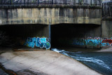
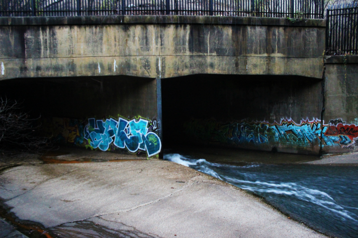
“The Jones Falls below North Avenue enters closed conveyance and flows to Harbor. During periods of extreme flooding, ponding occurs at the upper end of the conduits and water flows overland down city streets to the harbor across the proposed rail alignment. ” – Baltimore Northeast Corridor Alternative Transit Improvements Volume II
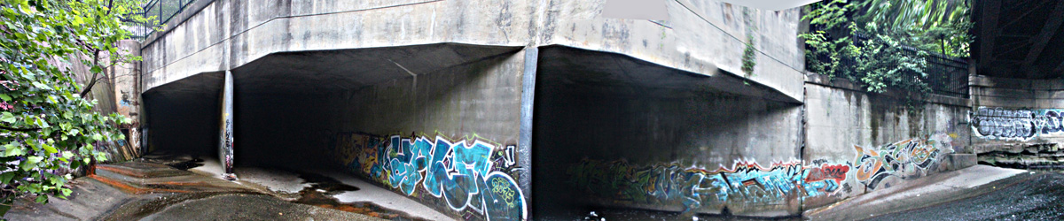
This is the point prior to the Jones Falls River going underground. This stage that leads to the tunnels or conduits are much newer then the other old tunnels of the system. It was constructed to cover the river further more, to make way for the Jones Falls Expressway (JFX) / Interstate 83 in the late 1950’s which is immediately overhead. It appears to be designed to accommodate a massive volume of water. Its difficult to estimate how much water could fit in here but it does appear that it could serve as a cache or a loading zone of sorts prior to going underground.
Its quite expansive.The river is encapsulated or channeled via a massive 6+ meter (20 foot) retaining wall on its eastern side. At the widest point, just before the 3 concrete box like conduits, its width is approximately 40 meters (130 feet) across. The river is brought up onto a smooth concrete expanse. It almost resembles a staging area, in that the river has a chance to smooth and spread itself out before dumping itself underground. Once the river is brought up to the concrete like stage, the grade drops significantly (as we will frequently see in this tunnel system at these sort of transitional points). The dry weather flow is channeled into the western conduit and always runs at velocity. Its not uncommon for the river to overflow into the center conduit during periods of heavy precipitation. The eastern conduit typically remains dry, except for small streams of water that leak out of the walls from the Interstate 83 above. During Baltimore’s flood of July 2016, the river was observed flowing into the Eastern conduit and wrecked havoc at the end of the central conduit prior to the first Junction Chamber.
There was a number of consecutive years that a well established yet “Bum Colony” or “Bum Encampment” resided on the western shore of this infall stage. Without flat out stating this location, I like to call this general area the “Forgotten Triangle”. It really presents a sense of remoteness and isolation. Your pretty much in the center of an industrial urbania yet on the same token your very isolated. In this forgotten triangle of land that sits low and surrounded by high retaining walls. A perfect location for a squatter one can only presume. Years later nothing is left from this Bum colony except for loads of trash and a resident cat that always makes his presence known to you across the river way.
Imagine what this place must look like with 15-20,000 cubic/ft/sec loaded up in it. This is the last place a man would want to be.
https://youtu.be/3PHqw-1_pW0?t=1m18s
Jones Falls Conduit System
Jones Falls River Infall Stage
JFX Intake/Infall Tunnels
JFX Triple Barrel Junction Chamber
JFX Diversion Tunnels
Guilford Avenue Junction Chamber
Old Guilford Avenue Diversion Tunnel
The Original JF Conduits Proper
WARNING:
The intent of these pages are to provide historical documentation. Many of the environments & areas presented on this website are hazardous, and were only entered on the basis of extensive training, experience, research and planning. Do not try to access these sites / tunnels / storm sewers , they should not be trifled with. The intent of these pages are to provide historical documentation for future generation. An explorer already risked their life, so that you can explore virtually from home… so stay safe, and stay away! Consider this neither a disclaimer, nor a recommendation.